staz from Australia

Previous Topic Next Topic
 
classic Classic list List threaded Threaded
5 messages Options
Reply | Threaded
Open this post in threaded view
|

staz from Australia

staz
Hi just checking out LibreCAD.

Just trying to do a land survey plan from some survey data.

Can you set the Y axis as North point at 0 degrees with clockwise increasing bearings?  
Can you use Degrees Minutes and Seconds?  0° 00' 00" to 359° 59' 59.99"
Can you use Gradians?

Thanks
Reply | Threaded
Open this post in threaded view
|

Re: staz from Australia

flywire
Reply | Threaded
Open this post in threaded view
|

Re: staz from Australia

dellus
In reply to this post by staz
You can't set 0 degrees as north or Y axis. In LC (and standard in CAD) O degrees is at 3 o'clock position, ascending counterclockwise.
For angle units see at Options - Current Drawing Preferences - Units, and Dimensions - Format units.

I have no experience with these, so you have to experiment yourself.  
Reply | Threaded
Open this post in threaded view
|

Re: staz from Australia

staz
Thanks for the reply.

Had a play around with some of the settings, but I can't seem to get the "Surveyors units" option working.

To my knowledge surveying bearings by quadrants is pretty much obsolete everywhere these days, apart from the USA.
(bearings by quadrants means that
  N E and N W measure from 0 degrees North
  S E and SW measure from 180 degrees or South)

Pity there is no way to switch so that clockwise bearings begin from North, the program would have more relevance to a wider audience.

For surveyors it is common to have a bearing of 35° 27' 50" entered as 35.2750 on the command line (just like you do on a scientific calculator - when the DMS angle option is enabled for data entry).
Reply | Threaded
Open this post in threaded view
|

Re: staz from Australia

LordOfBikes
Administrator
There are requests about GIS or COGO features from time to time.
Also announcements from people who plan to work on it. Maybe there are some forked repos on github, but I never heard of a released LibreCAD with GIS/COGO support.
I assume that the modifications are underrated and the projects come to nothing.

Beside the differences in coordinate systems, the huge dimensions are a big issue too.
Compared to a mechanical drawing or architectural plans the coordinates are way bigger, which leads into precision and tolerance issues with floating point math.

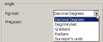
Maybe the surveyors units are a hangover from one of these attempts.
I can't say how they should work or if it should work at all.
investing less than half an hour into Search function can save hours or days of waiting for a solution