Re: LibreCAD for mapping?
Posted by R. van Twisk on Jul 04, 2011; 12:49pm
URL: https://forum.librecad.org/LibreCAD-for-mapping-tp4549798p4549904.html
Frans,

URL: https://forum.librecad.org/LibreCAD-for-mapping-tp4549798p4549904.html
Frans,
thank you for your kind words,
With LibreCAD you can load a PNG and later draw on top of it
and export the line drawing as a DXF.
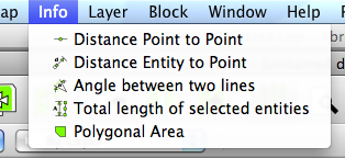
You can also calculate the area of a given set of points,
using the area tool, use the measure icon on the left.
or in the menu (with latest version in github):
This will give the measurement in 'units'. If the program is set to m.
And the area states 10000 then the number of sq/meters is 10000m2.
I agree there would be some room for improvement there to show for example
0.1km2 or 1h (hectare).
About the helpfile, I know there are some issues with that, and I am trying
to resolve that. What version are you currently using? a RC1 'should' work,
if it doesn't then I would need to take a look at this.
Would you be available when I create a new installer to see if it works?
Ries
On Jul 4, 2011, at 7:08 AM, Frans [via LibreCAD] wrote:
Ries, Firstly congratulations on a very good program.
I am working for Department of Agriculture (Soil Conservation services) in South Africa and I want to try something different with LibreCAD. My job is doing and teaching ranch/farm planning for farmers, which entails the drawing of a map of the ranch with the existing infrastructure (fences, paddocks, pipelines, roads, etc.) and then also draw new proposed improvements on the map.
How I am doing it at the moment is:
I identify the farm on Google Earth. Then I add placemarks as reference points on the GE image and I measure the horizontal- and vertical distances between the points and then save the bitmap image.
Then I go to my CAD program (I am using AllyCad), I load the bitmap as a background image. I measure the distances between the reference points that I added on the picture and then scale the size of the bitmap, untill the distances between the reference points are correct. Then I draw my map on top of the background image. It is important to be able to measure the sizes of the different camps/paddocks, lands, etc. on the map.
If this can be done by using LibreCAD it will enable many farmers to draw their own affordable farm maps instead of paying consultants to develope it for them.
Do you think it will be possible to do this in LibreCAD?
I do not see the function for measuring an area in hectares or sq meters.
Can I load a bitmap image and draw on top of it?
I am using Windows XP and the Help file does not work on it.
Thank you and keep up the good work.
Frans
If you reply to this email, your message will be added to the discussion below:http://librecad.1049103.n5.nabble.com/LibreCAD-for-mapping-tp4549798p4549798.html
| Free forum by Nabble | Edit this page |