Currently, all internal properties(coordinates, to be specific) are kept as standard 64bit floating points.
This would cause precision issues, if a geometry, which is created around the origin, is moved to 1,000,000 m away.
The trouble starts with some internal tolerance of 1e-10. Using 64bit floating points, (1,000,001 - 1,000,000) starts to have rounding errors around 1e-10. Since we have to do multiple rounds of floating point calculations, the rounding offs quickly magnified, and starts to get noticable.
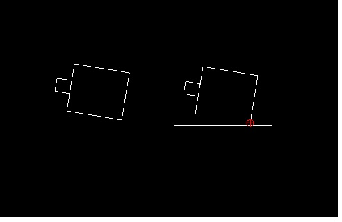
Another issue could be rendering, our rendering sometimes is not 100% following the logic positions. Especially, when you draw connected arcs, move/totate, and zoom in to connection points.
Holdstrong wrote
Thanks for responding. I said I was a beginner and havnt used splines. You might be reading more complexities into this.
By way of further background the polylines in the file are short segments of straight lines (between a metre and several metres in length) which are combined as polylines to create the feature / contour on the map. To cut out an area of interest (primarily to reduce the file size) I exploded the polylines, cut out the unwanted bits and then reformed the reduced polylines using the “Create Polylines from Existing Segments”. Crude and long winded but it worked to maintain the structure of the existing file.
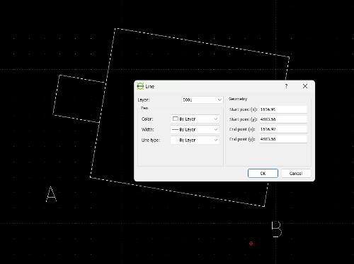
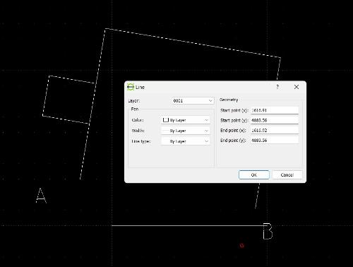
When I started to manually update features (and didn’t create polylines) the coordinates changed when using the Properties function. The attached screenshot shows how the line changes after doing a “Properties” on the line. The shape is about 10m square and the new line (I expect) is based on a 10m grid.
I assume the issue is caused by being so far away from the origin. A couple of meter difference in 500,000 metres is not significant except when the other local / connected features don’t change by the same amount !!.
I note what you say about precision but have noticed in the past lines “drifting” by fractions of mm’s on house plans. Not significant, and still accurate to a whole mm, but all the same a little surprising.